
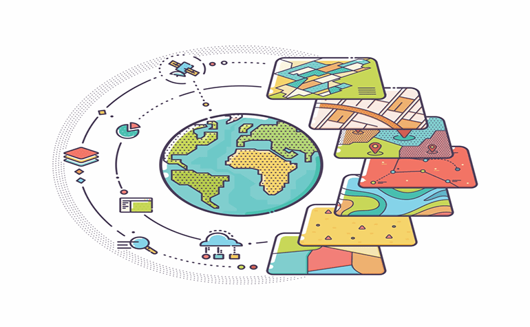
In the rapidly advancing world, GIS emerges as one of the technology that has a broad application in nature, science, humanities, engineering, and management. The use of geospatial technologies grow rapidly and it influences our life directly or indirectly.
1. What is GIS
Geographic Information System is a framework for capturing, storing, checking, and displaying data related to positions on the earth’s surface. It helps you to understand spatial patterns and relationships. It uses information that includes locations. Location can be expressed in latitude, longitude, address, or postal pin code. Different information can be compared using Geographic Information System. That information can include population, income, and gender. It can also include information about landscapes such as rivers, vegetation, and soil type.
Information about factories, farms, schools, streets, roads, etc. is also included in it. With Geographic Information System you can compare the locations using different data, how they relate to each other and accordingly take a decision.
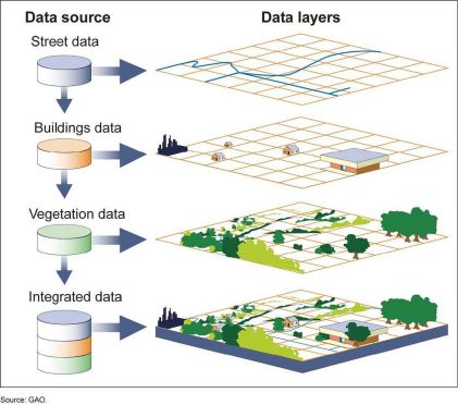
(Source: GAO)
2. Application of GIS
After computerization, Geographic Information System’s application is not limited to a specific field. It has a wide range of applications in nearly all fields, so it is equally important for people from different domains. Some of the application are:
I. Urban planning:
Geographic Information System helps urban development authorities to analyze the urban growth and its direction, also enable them to find suitable sites for further development.
(Source: geospatialworld.net)
II. Environment impact analysis:
The impact of construction and operation of highway, rail, roads, pipeline, and waste disposal are studied by using the Geographic Information System, and enable environmental engineers to decide according to it.
(Source: desktop.arcgis.com)
III. Agricultural application:
It can be used to analyze soil data to determine the best crop to be grown in a specific type of soil.
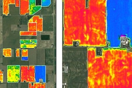
(Source: satimagingcrop.com)
IV. Navigation:
Geographic Information System is used to defining the better routing for ferries and ships.
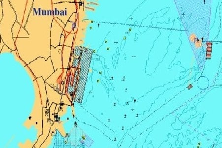
(Source: researchgate.net)
V. Soil mapping:
Soil mapping provides information about an area. It helps to understand soil suitability for various land use. Geographic Information System helps you to identify the type of soil in a particular area.

(Source: omafra.gov.on.ca)
VI. Defense purpose:
Analysing the changing terrain for the battlefield is essential in modern war. So the analysis of terrain help in the execution of military plan and deployment.
(Source: solutions.arcgis.con)
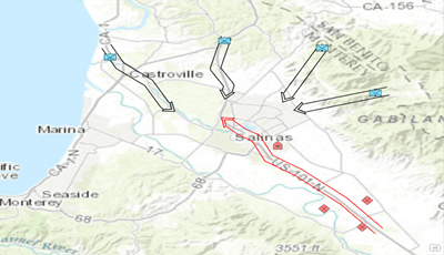
VII. Disaster management:
Geographic Information System helps you in risk management and analysis by displaying area which is prone to natural and man-made disasters. So, by identifying, the preventive measurement can be taken.
VIII. Pipeline route selection:
Pipeline route selection is a very complex task. Geographic Information System enables you to tackle this complex task efficiently. It will bring cost reduction and better decision making.
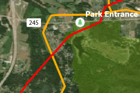
(Source: bernheim.org)
3. Skills required to Learn GIS
Qualification and skills matter a lot for a graduate who is willing to pursue the GIS course. It is best suited for the student having an understanding of environmental science, geography, wildlife, botany, forestry, ecology, etc., apart from education, skills of programming, database, drawing, and visualization are also advantageous for the candidates willing to pursue a course in GIS for career development.
4. Career opportunity in GIS
Nowadays, due to the intensive use of GIS, not only the Government but also private organizations hire GIS experts. The most successful GIS professional build their career with multiple skills set and become:
I. GIS Manager: You need to have a broad knowledge of GIS applications, compatibilities, and system requirements. You will also be responsible for planning the overall structure of GIS within the organization.
II. GIS Analyst: You require specific knowledge of computer operating systems, GIS software and its application, GIS concepts, and GIS database application design concepts. As a GIS analyst, you will have to conduct case analysis of business functions to establish GIS application requirements, plan and designing the analytical procedure and methodologies, and cost estimation for GIS development activities.
III. Map Designer: You need to have a strong knowledge of map design principles, graphic composition, and map production methods. You have to compile and integrate map data for automation from different resources and design high-quality maps and graphic products for output.
IV. GIS Application Developer: Being a GIS application developer means you have to create a custom application to meet specific user’s needs.
V. Database Administrator: The database administrator is primarily responsible for the spatial and tabular database of the GIS. You will oversee the data automation and maintenance and be involved in detailed database design and maintenance of standards related to data entry and updating.
VI. GIS Coordinator: Being a GIS coordinator you will have to plan, organize, coordinate, and participates in the development and implementation of the organization’s GIS to meet end-user service objectives.
5. How Orena Solutions Can Help You?
Professional courses validate individual knowledge and skills within specific areas of GIS. Orena Solutions is a leading ICT firm that offers two days introductory course on “Introduction to GIS” through experienced and certified industry experts. Undergoing an introductory course you get an overall idea about GIS, which enables you to enrol in domain-specific courses afterward for your career development. For more information, you can write to us at orenainfo@gmail.com or call on +91-9824347721.
Add a Comment